A cut slope behind a commercial warehouse off I-35W started showing tension cracks after a week of heavy rain. The owner called us because the cracks were widening. The slope was only 18 feet high, cut into weathered Eagle Ford Shale — a formation we know well across Fort Worth. It had been standing fine for two years, but that spring storm cycle saturated the upper clay layer and triggered a shallow failure plane. We mobilized within 48 hours, ran a site reconnaissance with hand augers, and set up inclinometer casings to track movement. In our experience, Fort Worth slopes rarely fail catastrophically without warning — but you have to read the signs early. A proper slope stability analysis isn't just a report; it's a diagnostic. That project ended with a redesigned slope geometry at 2H:1V and a toe drain that still works perfectly today. When we evaluate stability in this region, we always pair the geomorphology with lab shear strength data because Eagle Ford behaves differently depending on weathering grade — and that's where generic assumptions get you in trouble.
In Fort Worth's Eagle Ford terrain, slope stability is rarely about the rock — it's about the weathered interface and where the water moves.
Technical details of the service in Fort Worth
Demonstration video
Risks and considerations in Fort Worth
Fort Worth's population surpassed 950,000 in 2023, and the pace of infrastructure expansion along corridors like Chisholm Trail Parkway and the northern loop continues to push development onto marginal terrain. Slopes that were ignored for decades suddenly become critical when a subdivision or drainage channel goes in at the toe. The city's average annual rainfall of about 37 inches is concentrated in spring and fall storm events — we have seen 4-inch rainfalls in 24 hours that transform a stable 2H:1V cut into a debris slide overnight. The Eagle Ford Shale contains smectite clays that lose significant strength when wetted; direct shear tests on saturated remolded samples can show friction angles dropping from 28 degrees to below 18 degrees. A slope stability analysis that uses peak strength parameters without accounting for this weathering and moisture sensitivity will overpredict factor of safety by a dangerous margin. We have also encountered undocumented fill slopes from the 1970s and 1980s, particularly near older industrial sites east of downtown, where no compaction records exist — those require a completely different approach involving back-analysis and conservative residual strength assumptions.
Our services
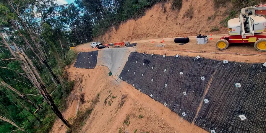
Every slope stability study we deliver in Fort Worth is built on site-specific data — not regional correlations from a database. The two investigation methods below form the core of our field program before any modeling begins.
Slope investigation and instrumentation
We map the slope face, log exposures, advance hand augers or hollow-stem augers behind the crest, and install standpipe piezometers or inclinometer casing as needed. This gives us the stratigraphy, the groundwater profile, and — if movement is already occurring — the depth of the shear zone. We sample the weathered/unweathered contact for laboratory shear testing under the moisture conditions that match the slope's history.
Limit equilibrium modeling and remediation design
Using Slide2 or SLOPE/W, we build cross-sections calibrated to the field investigation. We run static and pseudo-static scenarios, test sensitivity to phreatic surface rise, and back-analyze any existing failures. Remediation options we typically evaluate include slope flattening, toe buttresses, horizontal drains, or — where space is constrained — soil nail walls tied back into competent shale.
Frequently asked questions
How much does a slope stability analysis cost in Fort Worth?
For a single slope assessment with field investigation, laboratory shear testing, and limit equilibrium modeling, the cost typically ranges between US$1,370 and US$4,410. The spread depends on slope height, access conditions, number of borings, and whether instrumentation like piezometers or inclinometers is required. A small residential lot slope with hand-auger sampling and one cross-section sits at the lower end; a commercial development slope over 25 feet high with multiple sections and groundwater monitoring runs toward the upper end.
What is the difference between a shallow and deep slope failure, and which is more common in Fort Worth?
A shallow failure involves the upper few feet of soil sliding along a roughly planar surface parallel to the slope face — typically at the contact between weathered and unweathered material. A deep-seated failure involves a curved slip surface that extends well below the toe. In Fort Worth, shallow translational slides in the weathered Eagle Ford zone are far more common, usually triggered by intense rainfall that saturates the upper clay layer. We see deep failures occasionally in tall cut slopes where bedding planes dip out of the face, but they are rare compared to surficial slides.
How long does a slope stability study take from investigation to final report?
A typical timeline runs three to four weeks. The first week covers field investigation — drilling, sampling, and installing any instrumentation. Laboratory shear testing on the recovered samples takes about two weeks for consolidated drained direct shear with multiple points. Modeling and report writing consume the final week. If the slope is already moving and we need inclinometer data over time to define the shear zone velocity, the study may extend to six weeks to capture enough readings for a reliable trend. More info.